Showing posts with label Orienteering. Show all posts

Sunday, June 16, 2024

The Chase: Patuxent River Park

 Today was the last orienteering meet of the QOC season, in beautiful Patuxent River Park, where I took my youngest back in December. This time there would be a chase start.

The way it works: Depending upon your course (I chose Beige, since it's been months I last ran an O), you have to do a certain number of loops. Each loop is different. While we all start at the same time, you don't necessarily want to chase the person in front of you. They might be on a different loop. Some courses share loops: brown today ran T along with beige. 

But before you can run your course, you have to drink. You have a choice of water or beer. Once the horn went off at noon, you had to drink your cup then run. When you finished your loop you had to again drink before starting the next loop. 

QOC also had a meeting. Officers were elected. A rough schedule for next season was decided upon. Food and drink were provided. Merriment prevailed. 

My first loop was T.


Control 1 was quite marshy, as was 2. To control 3 I stayed down by the water, but about 2/3 of the way I moved up till I found the control. Then the long march to 4. I took a bearing and just went for it. Past the trail and on to the road. Imagine my surprise when I hit that little square on the map on the north side of the road. It was a deer enclosure.


Then I took a bearing from the enclosure and ended up at control 4 perfectly. I got cocky at that point and congratulated myself on the perfect navigating. On the way to control 5 I went too east and saw the building and went straight south to the trail. Control 6 was back at the start and control 7 was the drink station. Then on to map O.


For control 1 (8) I stuck to the trails. Didn't see the control till I was on the eastern side then it was down in that reentrant, which I scooted down on my butt. On the way to 2 I went north from 1 to the trail and south till I was parallel to control 1. There I took a bearing and walked to control 2. I stopped at the dirt road and went north to the trail and followed it to the road. The trail was called Green. It continued north from where it first hit the road, so I took it. I stayed on that trail for about 200m till it turned south and followed it for a while. The depression was easy to find. Back to the road and up to the open area where it was a short run to the tree, then back to the drink station, downed my cup of water, and beeped the finish control. 

1:22.15. Seventh place out of 16, so happy with that. 

Saturday, April 27, 2024

Spring Bloom

 Today, Sonja and I participated in Broad Run Off Road's Spring Bloom adventure race. We did the no-bike option as we have plenty of hobbies already. We don't need another one. We have thought how funny it would be to sign up but show up with our fixie bikes. But then we saw some of the bike trails today.


I'll tell you the end up front: we got 15 points (1 point per control) and placed 13th out of 29 two-person teams and 25th out of 49 total for the no-bike option. We're getting better!


The race was 5 hours long. All of us no-bikers had to start with the paddle. If you, dear reader(s), remember my report from BROR's Fall Foliage, Sonja and I suck at paddling. But not today. We actually did pretty well!


My iPhone stopped tracking us as soon as we got in the water, so I had to use Google Maps at home to see how far we paddled. We got controls P1-3 on the map (below). Ended up canoeing 5km! 


Once we got back to the paddle S/F, we dumped the canoe and ran to the picnic area where we changed into rain jackets (because yes, rain again) and began the trekking leg. We entered trekking 1:25 into the race. 

Everything to the east of the railroad tracks (going up the fold in the pic above) we got, in order, T1-5. We did all that in only 46 minutes, which is great for us. We got our first "bike" checkpoint (B1) at 2:23 race time. (Us no-bikers were allowed to get B controls; those doing the full adventure race could only get controls when they were on the proper leg.) T6 took a minute; the hint was firewood, but there was a Boy Scout troop in that area. I assumed they wouldn't want us to walk through their camp, but sure enough, the control was in it. We almost missed it but one young man said "Did you get that one?" and pointed to their camp. Thanks, Scout!

Then we were on the other side of the tracks at around 2:30. So half done. T7 was easy, but T12 was harder. We were on the road going for T11 when I told my wife about the marshy T12. That one, unfortunately, took us 22+ minutes. Not because we couldn't find it. We saw it clearly, but the whip vines and the fact that we were on the wrong side resulted in us taking more time than we hoped. We then hopped back on the road and headed to T10. After T10 we went back to the trail. Initial plan was to turn left, hit B5, then T9, B2, maybe T8, B3, T7 then back to Finish. 

But we decided to turn right. Sonja wanted to go for a "far one." And we did. But T10 to B6 took us 21 minutes, and we had to cross about 200m of muddy and slippery wooden 2x4's. I really thought it would have taken us longer. But from T10 to B6 to B5 was a total of 41 minutes. I wonder if we could have gotten T9 and B3 in that time (2 points rather than 1)? Oh well. It was still fun. 


We still got B5 and then headed to S/F. We clocked in at 4:42.35, so didn't lose any points for being late!


Wednesday, March 6, 2024

Winter Wildcat 2024

 Over the Presidents' Day holiday, Sonja and I competed in the 2024 Winter Wildcat, hosted by Tanz Navigation. We did their event, The Search for Big Mack, back in September and loved it. We learned a lot during that event (like: be on time!) and intended on applying those lessons learned to this event. 

And we did! We did not arrive late! In September we lost 5 points per minute; in Winter Wildcat we would have lost 50 points per minute. We didn't lose any. w00t!


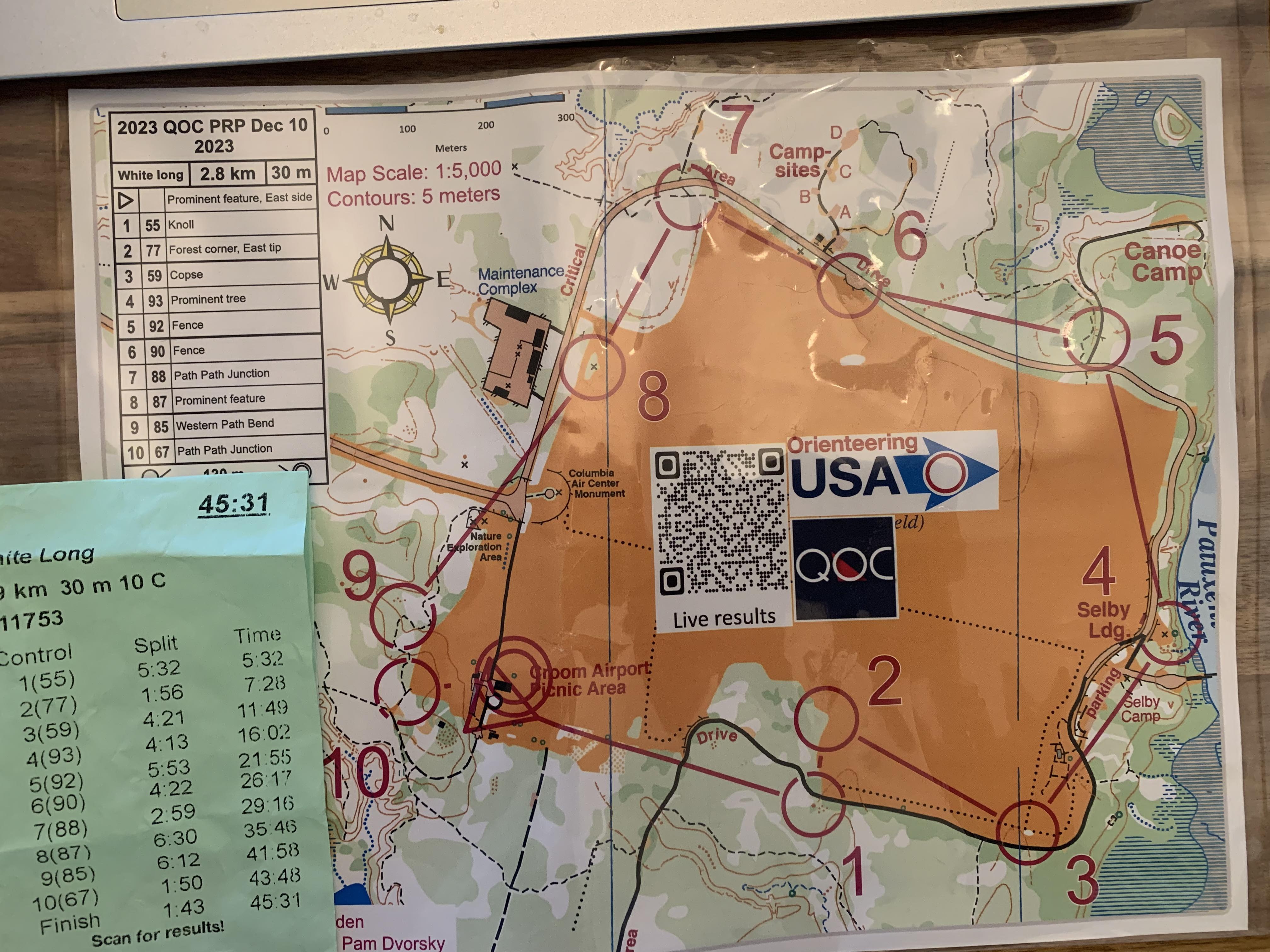
We were handed 3 maps Sunday morning, overcome by choices! Here's the East map:


That blank spot center top was interesting. At 7:55am, the race director put the missing rectangle up on the screen. You had as much time as you needed (note: 8am start) to draw the controls, contours, features. We didn't even consider going east. 

Here's the south map. It'll come up near the end of our story. 


Like I said, this map will feature at around 4pm or so that Sunday. And here is the map we spent most of our day on:


Note the folded over edges. That was so the map could fit in my map bag*. If you go to the Routegadget site for Winter Wildcat, you can follow our track. (Our team name is MTheads. Scroll down to Sunday only teams. Click both boxes when you get to our team. And you should probably press the + after you press play. In fact, press + a few times, otherwise you'll be sitting looking at our track.)

*A map bag hangs around the neck and has a see-through window on both sides. Here's an example as well as a pic of mine:


We first head downhill to 43, where we met a nice couple of military dudes who has also done Saturday. Following 43, we went down the road to 93, pretty easy to find considering it was worth 90 points. That gets us to about 45 minutes into the race.

We didn't do either of the Orienteering courses in The Search for Big Mack. This time we wanted to do the one and only O course, get a bunch of points (10 controls, 55 points each!). That's where we went next. And that course took us a bit over 2 hours, but I'm happy to report that we found each control right away. My nav is getting better and better. Some we crazily placed, on the side of a cliff. Thank God for my wife with her cat-like agility. 

This Scout base was so beautiful, I'm terribly jealous. Each camping area has a huge tower, probably 50' high. Very easy to see, and on the maps thankfully. We loaded up on water and headed over a beautiful bridge to control 53, already at 685 points!


53 was way deep, again thanks Sonja. Then up to 62 and 72, both easy to find. 72 was especially fun; it was an old wall tent and the control was inside. I didn't see it and was about to ask Sonja which side she wanted to walk around. But she was short enough to see the control inside! And that brings us to a bit under 5 hours. 

After 82 and 32 we had some decisions to make. We were at 5:40 and could have walked over the dam and start the walk back (to avoid late charges). But it was still early so we decided to go get some of the controls around the lake, worth 100+50+40, so well worth the 40 minutes it took us to walk that far. 

After that we marched on to an area that made me seriously jealous: a couple of huge and high zip-lines! Not to mention the great rock climbing areas. They were wonderful to use as nav points. We almost went to 40 but the cliffs and the way to get to 40 didn't seem worth it, instead went to 50, which Sonja climbed up to while I looked at maps. 


And that's where our issue started. Because of the time (we had some), we wanted to grab 30 and 83 south of 50. I pulled out the south map and put it on the back side of my map bag. After 83 (we never found it and I'm still pissed about it) we were at 7:40, so plenty of time. We decided to walk north up and around past 43, because I saw, as I flipped my map bag back-and-forth, the road will have a smaller road come up on the right which turns 180 and heads right up to the S/F building. So we started walking. 

When we passed 43 (at 8 hours), Sonja reminded me that we had gotten to 43 quickly and easily. I wasn't ready for so much uphill; bring on the easy road. 

There was no easy road. We walked another 11 minutes before I realized my error. The cliffs were telling. There was no road branching off and we were bound for another 2km of walking south if I hadn't noticed.

So we turned back and fast-walked to where the cliffs ended. We had seen a team going straight up the side of the hill (turns out it was about 50m straight up) and poo-poo'd them (I did at least). Well now we were walking up in their footsteps. This whole error cost us 30 minutes. 

Then we clicked the finish. Unfortunately too early because there where you finish was also the Memory-O, where you get to look at a map, then put it down and go find your controls. We still had a smidge over an hour at that point and maybe could have gotten a couple more controls. But alas, no. 

Still okay with it. Didn't lose any points due to being late, which is an improvement. Other lessons learned from Winter Wildcat: Sonja should bring her sunglasses; she was practically blind during the O which was in the open and snow covered and quite sunny. I need to put my glasses in the front pocket of my vest; I had to ask Sonja for help when I changed out from clear to sunglasses; and finally, and most important: have Sonja check my route. I'm certain she would have seen the mistake I made with roads. We ended up #102 out of 120 total teams, #16 out of 20 mixed sex teams. We'll take that!

Us before we started. No pics from the after. We were too busy stuffing our faces! Thanks Mark & Lora for another great Tanz event!

Monday, January 22, 2024

Last week's swimming, orienteering, lifting...

 Almost did three days in the pool this week, or at least that was the intent, but weather cancelled Tuesday night's session. And Saturday's session. Of course, I wasn't going to go due to QOC running an O meet on Saturday. I was going to try my first advanced course (beige). Alas, QOC cancelled Saturday early (on Wed) so okay, I'll go swim. 

But no. Due to Friday's snow and cold temps, the rec center where we swim decided to open late Saturday, thus cancelling my morning plans. Oh well, only 2600 yards last week in the pool.

Sigh...

This weekend another O meet is sked. Unsure if I'll try the advanced or not.

But, got a lot of cold walking in (come on, brown fat). 22+ miles specifically with the wife and dog. In the cold. 

Lifting went well.

Monday, 15 Jan (H)

  • SQ: 3x3 @265#
  • OHP: 3x4 @102.5#
  • CR: 4x15 with 24kg kettle & 20# vest
Wednesday, 17 Jan (L)
  • SQ: 2x5 @215#
  • db BP: 3x12 w/30# db
  • CR: 4x12 (same as Monday)
Decided to mix it up on L day with respect to overhead press. Tried dumbbell bench press. Goal 3x12-15, started with 30# dumbbells. Next week I'll try 3x15 and if I do it, then I'll go up to 35# dbs.

Friday, 19 Jan (M)
  • SQ: 2x5 @230#
  • OHP: 2x5 @95#

Edit after I published the above: So, my wife. She's joined the Y recently. Up to this, she'd been deadlifting with a hex bar in our garage. The Y doesn't have a hex bar. So today she loaded 185#, which she can lift for multiple reps (she weighs all of 108 pounds soaking wet). She's really strong. Today she lifts and the one rep is hard. But she completes it. Then she deloads the bar, only to discover she had just lifted 205#. (Her PR from years and years ago is 210#.) My wife is incredible.

Great songs listened to last week: "The Indigo Streak," by Greta Van Fleet; "It's Saturday," by Marcy Playground; "Le Disko," by Shiny Toy Guns; "Who Put You Up to This?" by Sunflower Bean.
Books read: Finished Hyperion by Dan Simmons; Anglo-Saxon Attitudes by Angus Wilson; and an author's second book due to my editing it.

Monday, January 8, 2024

QOC Fountainhead

 On Sunday I attended QOC's Fountainhead orienteering meet. I ran the Orange course; still running the intermediate courses until I'm well under 2 hours. Don't want to try and jump to Brown/Beige (advanced) until then. 

Well, got my second under-2 hour Orange under my belt, despite my 40+ minutes trying to find control 4! One, two and three went so swimmingly I got cocky and thought "Maybe I'll be at an hour thirty!" Then control 4. 


If you can see, there was a trail between 3 and 4, along the river. Coming off 3 I got on the south trail (near the number 8 in the map) so backtracked and got on the trail. But where I was, counting the reentries, I was way off. I tried to cut south to cut the times but then thought I was on the wrong trail again. Finally I got on the right trail but began to worry as I couldn't find the right spot to head NE to the rootstocks. Then I saw a flag on the right and damn, wrong side. Sure as crap, it was control 5. Well damn.

So I got back on the trail and went up to 4. Instead of turning around, I took the trail south toward control 6, took a gander at it so I'd remember, then went back to 5, turned around and quickly to 6. Control 4 to 5 I did in 10:31, 5 to 6 in 4:58, then nine minutes to 7. Control 8 was fun as that little loop coming off the main trail was for mountain bikers, large wooden mini-bridges and boom, there's 8. Nine took a while since we had to go around the water. Control 9 to the finish took 8 minutes, lots of contour lines to go through and then when I got near the start, I couldn't find the finish at first. Of course, I saw someone starting with a basenji (like our dog!) but hadn't finished yet; once I beeped done the basenji was gone. 

Final time 1:50:26. If I could have found 4 in a decent time (10-ish minutes) that would have brought me down significantly. From 25 out of 37 to 16 out of 37! 

Tuesday, December 19, 2023

QOC Turkey Run

 Wife, dog and I ran the Orange course at Turkey Run with QOC on Sunday. It was a great time! Way long. That 5.3km (whatever) turned into 15-ish. Yes, yes, I know they measure control to control as the bird flies, but jeez. I was all over the place. 

I have no map for you because I tried the Livelox app. I started it, but was unaware you also have to attach your run to a course, so when I got back, no map. (Besides that, the app is kinda messed up. Lots of all black screens where the font and background are black.)

But, 16K steps. So that's kinda nice. 

We ended up 6 out of 8 teams. Pretty good considering we had a dog on a leash who wanted to always walk the opposite side of the tree than my wife's chosen route. But I ended up finding all the controls without missing or passing them, which made me happy. (Almost 3 hours, so the last Orange I did at just under 2 hours is still my best.)

What I liked about this one was the first half took us far off. Made us use parts of the map that weren't trails. I aimed off going 1 to 2 and again 2 to 3. 4 to 5 was trails, 5 to 6 we took the trails then road all the way up to the rootstock then went direct southeast to 6. 6 to 7 we again took the road and trails, passing 8 which we saw (w00t!) on the way to 7, back to 8 right quick. For 9 we aimed off then up to 9, back to the creek down to 10 (which we saw on the way to 1), then 11 to finish, which I could barely find! So much fun.

This is it until after the New Year. Thanks QOC for a great start to the season. Great bunch of folks, so friendly and supportive of us newbies.


Monday, December 11, 2023

Taking the daughter to work

 Took my 20-year old to an orienteering meet yesterday. It was great fun. 

The O-meet was at Patuxent River Park. There were a lot of courses available, but as this would be my daughter's first time, I signed us up for White Long: 2.3km, 30m elevation, 10 controls. 


We walked the entire course, finishing in 45:31. If we ran, my daughter says, we would have finished in 20-ish minutes. "That was a baby course," my daughter said. Yellow at a minimum from now on, according to her. 

I had fun teaching her the basics. Looking forward to the next time when she and I run a Yellow course. 


Monday, December 4, 2023

Mid-Atlantic Orienteering Championships

 Sunday I took part in the Mid-Atlantic Championships, hosted by DVOA. QOC went en masse, even rented a huge bus (I did not ride along). I took part in the relays as part of the club, but did not take part in the classic for points for the club. Reason? For my age and sex, I would had to run a Green course, two course levels more advanced than Orange! 

So I ran the "Rec Orange" meaning no points (beyond participation points) and the Relay. The Relay was fun: three orienteers run one after the other. The first leg, mine, was a Yellow, 1.4km, slight elevation gain, 8 controls. Did it in 17-something minutes. Second was a bit longer at 2.25km, Orange, 10 controls. Last was advanced, 2.52km, 10 controls. I was assigned a relay with the QOC president and one poor advanced orienteer who just came back from running the Blue course (the most advanced) about five minutes before he had to start the third leg of the relay!

QOC put the relays together based on our per-km pace in previous meets. They also named us; we were Tortises (yes, spelled that way) and were #20 of 22 relays. No points, sigh.

My Orange was fun but I literally got completely lost between 2 and 3. I had to take a safety bearing till I could find civilization, then went back to my last known point (hello, control 2) and start over. Thus all the time it took me on those controls.


I was happy with this. Thought I'd miss the relays I was taking so long, was frankly surprised I came in under 2 hours.


Got a lot of steps in, that's for sure. Almost 19,000 for the day. Didn't get a map of my relay, but here's my Orange:


It was a two-hour drive up and due to traffic a 2.5 hour drive back, the only negative. I met a bunch of QOC folks up there and will endeavor to remember all their names when I see them again. They're all so nice!

Lots of fun. Would definitely attend again, despite the drive. Those relays...so fun.

Pictures!

Me coming in behind my new QOC friend Sharmagh


THE team. Of studs. 


QOC showed up!

Friday, November 24, 2023

Search for Big Mack Rogaine

 The wife and I competed in a fun, tiring orienteering event in September. A rogaine is an endurance orienteering event that lasts for hours (and sometimes days) in which your team has to find as many control points as possible in a very large area. The Search for Big Mack was held in the Blue Ridge Boy Scout Reservation, all 17,500 acres of it. We had from 8am to 6pm to find as many controls as we could. We didn't find many! They were hard. But we did walk a lot. And I mean, a lot. Over hill and dale. Up and down (the worst). We ended up walking a bit over 18 miles in those 10 hours, with but one 20-ish minute break to eat and refill water bottles. I ended up walking 50,830 steps in that 10 hours. (My week's total step count was over 124,000!)

So this is our map before we marked it up. (Click on it to follow along.) The start (S/F) is way over on the left by that lake. Each black-outlined square is 1km x 1km. To give you some context, if you take the straightest possible trails from the S/F to the lake on the east side (right), that's 5 miles of walking (elevation gain and loss along the way).

You will see small purple circles peppered throughout that map. The tens digit of each control is the point-value of that one, 4 the easiest (supposedly) and 9 the hardest. Here's our map after we planned our route:

Plan was to head south along Big Mack's trail and make our way about halfway across the map, then cut up Gumstand to Greenwood Road for a bit, then up Oak Hollow till Little Laurel Creek all the way to Ottari camp. There was a standard orienteering course set up over there. Figured we could get over there by noon, run the O course to get a lot of points, then head back along Little Laurel, take a right to get control 87 (at the summit; my wife wanted to do one "high" control), then back down Little Laurel back to Greenwood Rd to Sidewinder trail back to the S/F camp where we'd do the orienteering course there, to be done before 6pm. (For every minute past 6:00 the team arrives, they lose 5 points.)

How naïve! The first two controls we got (84 and 44) took us about two hours. We looked for 65 for way too long and never found it. We went on to 55 then up Gumstand. 56 took us forever because we went down the wrong (mostly dry) creek first. But we finally found it after going up the wrong reentrant. Once we hit Little Laurel Creek trail we had to make a decision. It was well past noon. We could skip the Ottari camp and head back, but I only had one bottle of water (of three) left and wasn't sure I could make it all the way back to camp and find controls with only that one bottle. So we made the decision to walk to Ottari, fill our water bottles, eat something, then head back.

Water refill & apples!

We learned something there. We should have taken our Lifestraw bottles so we could just grab some creek water. Or iodine tabs, because we ended up at Ottari around 2pm. We still thought we had time to get back. We tried for too long to get 47; that wasted time and was thirsty work. We were excited that we got 97. It was up that reentrant quite a way, but 9 points! Then the long slog up (those contour lines are 5m apart; from 97 to the intersection was about 100m of elevation gain. I got us lost then. I thought we were at the intersection of two trails a bit SW of 85; but our intersection had a trail going WNW and one going ESE, but that made no sense from where I thought we were. Plus there were signs for trail North Ridge and Matheny's something, neither of which is anywhere on the map. So we took the WNW trail and boom, ended up at 87! That wasted plenty of time and those 8 points weren't worth it in the end (spoiler alert: we were 6 minutes late, thus lost 30 points).

So down we went along Little Laurel, knees hurting, something like 200m of elevation loss. I was limping by the time we got to Greenwood Rd, at just about 5pm. There was no more looking for clues, we just fast-walked up to Sidewinder, then switch-backs till we ended up on the back side of the start building (dining hall), checking in at 10:05.44. 6-minute penalty.

Our score sheet

We ended up getting only 7 controls totaling 45 points, but with the time penalty of 30 points, our final score was 15. (We're particularly proud of 97 and those two 8s!) The after-party was funny to look at. Even those teams who got 18+ controls and ran both orienteering courses were walking around like my wife and I. One of the volunteers (thanks Lora!) made fantastic chili, both vegetarian and "mammal and poultry" chili. (My wife asked her about that. Lora has a friend who got bit by the tick that made her allergic to meat from mammals: my nightmare!)

And we weren't last! We were 27th out of 30 teams. I'll take it. Not so bad considering our relative newness to orienteering!

My chili with Doritos: been years since I had those!
Wife's chili with standard tortilla chips. And she had beer!


Fall Foliage Adventure Race

 On October 14, wife and I did the Fall Foliage Adventure Race. This group (Broad Run Off Road) puts on two a year and offers a "no bike" option, which is nice. Most adventure races have at least three elements: foot, water, bike. Bikes are kinda expensive so it is nice to be able to try one of these out w/o having to commit to two mountain bikes. (The organizers provide the kayaks/canoes.) It was a blast. Usually these races have stages that you progress through, e.g. stage one Trek to the boats for stage two, then get out of the boats for stage three, trek again. But as our area didn't get enough rain and the lake wasn't full enough, the organizer decided to make ours a "choose your own adventure" type race. 18 checkpoints (CP), get them in any order. The only rule being if the CP is blue, you have to get that from a boat.

There were 49 teams, from solo to a team of four (and lots of families with kids which was great to see). To prevent all 49 teams (100-odd people) from hitting the trails or boats at the same time, the organizers devise a puzzle to delay the start. Last year they gave every team a Lego set (number of pieces based on size of team, I believe) and you had to build it then turn it in before you could start. This year, each team got a lock with their team number on a tag and you had to use a hint sheet to figure out the lock's combo, then go turn both the lock and the tag in before you could start. Wife and I solved ours in less than a minute! We chose to Trek first.

We knocked the first five CPs out in about an hour and had to make a choice: continue around the lake? (We were only about a quarter around.) Run back and get a boat? We decided to go back and get a boat. We ran back, got the canoe in the water, and to the other side of the lake (it's about 3km long) in less than an hour. But we were horrible canoers. We couldn't go straight. Then we spent over 50 minutes finding a "land" CP from the shore, not getting lost but way off course (thus the 50 minutes), which got us just past 3 hours.

Time limit 4:30, and we didn't want to be late; 1 point lost for being late, then another point lost for every 5 min till you're 30 min late which means DQ. And each CP was only worth 1 point, so you really had to decide if that last CP you were going for was really worth losing its worth by showing up late.

We got a couple more CPs off the water and were about to start for another one when we realized we only had a half hour left and were about a kilometer from the boat launch, so we headed back, turned in the boat and ran to the finish.

Clocked in at 4:08.11. Somehow we only got credit for 10 CPs even though we went to 11. (The one we didn't get credit for, CP4, did only faintly beep so I think maybe the battery was dying.) Ended up covering 13.5km and a shit-ton of steps! And soaking wet as it rained the entire time.

Unsure if we'll do the one in Spring, but maybe? Oh, and before you ask, dear reader(s), No, swimming was not allowed. (It looked so nice, too, and close.)

Winter Wildcat

 Pictures day two. Pictures day one